
Lidar, an acronym for "Light Detection and Ranging," is a technology that has gained prominence in recent years due to its applications in various fields such as autonomous vehicles, topography, forestry, and archaeology. It works by emitting laser pulses and measuring the time it takes for the light to return after bouncing off objects. This information is used to create detailed, three-dimensional maps of environments called point clouds. In this blog, we'll dive into what a Lidar scanner is, how it works, where it is used and much more.
What is Lidar?
Lidar is a remote sensing technology that uses laser light to measure distances and create high-resolution 3D representations of the surrounding environment. The term "Lidar" is an abbreviation for "Light Detection and Ranging" and is sometimes also referred to as "laser radar" or "laser scanner." Lidar systems emit laser pulses and measure the time it takes for the light to travel to an object and return. By analyzing this data, the distance between the Lidar sensor and the object can be calculated.
Lidar can operate in different modes, including airborne Lidar (mounted on drones or airplanes) and terrestrial Lidar (mounted on ground-based vehicles or tripods). Depending on the specific use case, different wavelengths of laser light may be employed, ranging from ultraviolet to near-infrared.
What is a lidar scanner?
A lidar scanner refers to the device or equipment that performs the actual lidar measurements. It emits the aforementioned laser pulses and measures the time it takes for them to return after bouncing off objects.
In essence:
- While Lidar is the technology or method
- Lidar scanner is the hardware that uses lidar technology to scan and measure distances.
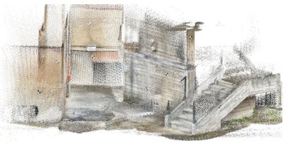
Lidar scanners produce a large collection of points as their output, which is called a point cloud. You can learn more about lidar point clouds here.
How Lidar works - principles of operation
Lidar systems work by emitting short pulses of laser light towards a target and then measuring the time it takes for the light to return to the sensor. This round-trip time is known as "time of flight" (ToF), and it is used to calculate the distance to the target based on the speed of light.
Here's a step-by-step process of how a typical Lidar system works:
- Emission of Laser Pulses
The Lidar sensor emits rapid bursts of laser pulses in a specific direction. - Reflection and Return
The laser pulses travel through the air until they hit an object, such as a building, tree, or the ground. The light is then reflected back to the sensor. - Time of Flight Measurement
The Lidar system measures the time it takes for the laser pulse to travel to the object and back. This measurement, combined with the speed of light, allows the system to calculate the distance to the object. - Point Cloud Generation
The calculated distances and angles of the emitted laser pulses are used to generate a "point cloud" of data points. Each point in the cloud represents a point in 3D space, providing a highly detailed representation of the environment. - Intensity and RGB Data
In addition to distance measurements, Lidar systems often capture intensity data (reflectance of the laser pulses) and, in some cases, RGB (color) data. These additional data layers can provide more information about the objects in the environment.
Lidar detection range, resolution and field of view (FOV)
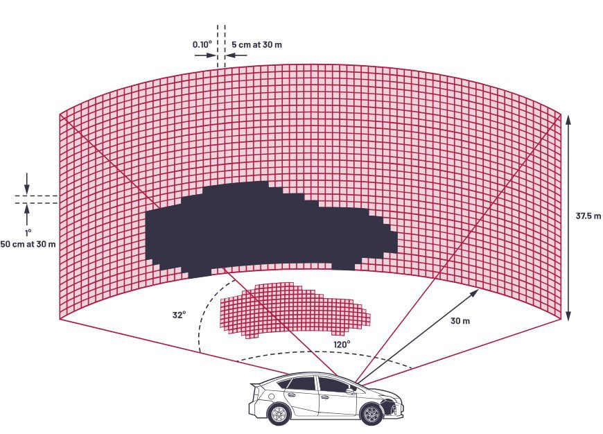
The most important parameters in any Lidar system are its detection range, resolution, and field of view (FOV). Together, these parameters determine the suitability of a lidar system for various applications.
Detection Range
The detection range of a lidar system refers to the maximum distance at which it can accurately measure objects. This range is influenced by several factors, including the power of the laser, the reflectivity of the target object's surface, and environmental conditions such as fog, rain, or dust. High-powered lasers can extend the detection range, but they require more power and can be more expensive. Typical detection ranges for lidar systems used in autonomous vehicles or drones can vary from a few meters to several hundred meters.
Resolution
Resolution in lidar systems can be likened to the clarity (or resolution) of an image. It defines how detailed and accurate the 3D point cloud data is. Resolution can be broken down into two components: angular resolution and range resolution.
- Angular Resolution: This is the smallest angle between two points that the lidar can distinguish. Higher angular resolution means the system can detect smaller objects and provide more detailed scans.
- Range Resolution: This refers to the lidar's ability to distinguish between two points at different distances from the sensor. A higher range resolution allows the lidar to differentiate between objects that are close together but at different distances from the sensor.
Field of View (FOV)
Field of view is the portion of the environment that can be seen at any moment by the lidar sensor. It is usually described in degrees and can vary significantly depending on the design of the lidar system.
- Horizontal FOV: This is the angular range that the lidar can scan horizontally. A 360-degree horizontal FOV allows the lidar to capture a complete surrounding view, which can be beneficial for a variety of applications.
- Vertical FOV: This is the angular range that the lidar can scan vertically. Vertical FOV is important for capturing the height of objects and the topography of the environment. For instance, a lidar used in aerial surveying might have a vertical FOV of 30 degrees to capture terrain features accurately.
Types of lidars
Lidar devices can be broadly categorized in two main ways: by their method of operation and by the platform they are mounted on.
Method of operation
- Mechanical Lidar: This is the traditional type of lidar, which uses a rotating mirror to deflect a laser beam. The time it takes for the pulse to reflect back to the sensor is used to determine the distance to the object. Mechanical lidars are a relatively mature technology, but they can be bulky, expensive, and have moving parts that can wear out.
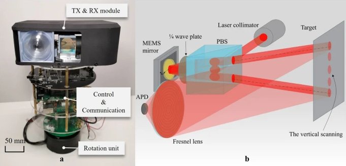
- Solid-State Lidar (MEMS): This is a newer type of lidar that does not use any moving parts. Instead, it uses a variety of technologies, such as microelectromechanical systems (MEMS) or optical phased arrays (OPA), to steer the laser beam. Solid-state lidars are more compact, durable, and potentially less expensive than mechanical lidars. However, they are still under development and may not have the same range or accuracy as mechanical lidars.
- Flash Lidar: Flash lidars illuminate the entire scene with a laser pulse at once. The time it takes for the light to reflect back to the sensor is used to create a 2D image of the scene. Flash lidars are very fast and can be used to create high-resolution images, but they have a limited range and can only create 2-dimensional maps.
- Frequency-Modulated Continuous Wave (FMCW): FMCW lidars continuously emit a laser beam that is modulated in frequency. The difference between the transmitted and received frequencies is used to determine the distance to the object. FMCW lidars can be very accurate and have a long range, but they are more complex and expensive than other types of lidars.
Mounting Platform
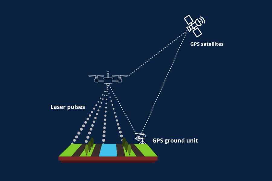
- Airborne Lidar: Airborne lidars are mounted on an aircraft, such as a drone, helicopter, or airplane. They are used to create high-resolution maps of large areas and usually operate at longer wavelengths (often near-infrared) to penetrate vegetation and obtain ground elevation data.
- Bathymetric LiDAR: Specifically designed for mapping underwater topography and bathymetry by using shorter wavelengths (green or blue) that can penetrate water.
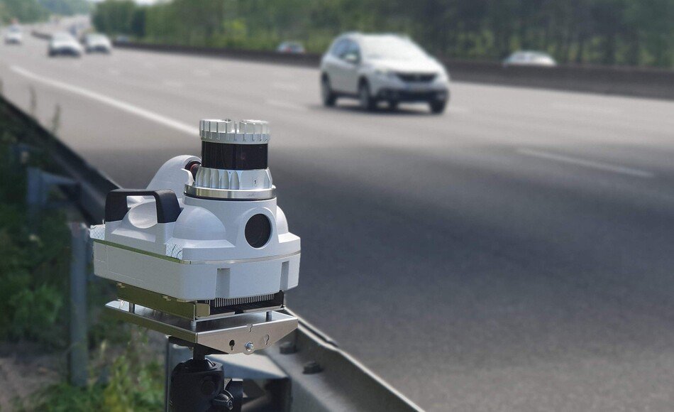
- Terrestrial Lidar: This type of lidar is mounted on a ground vehicle or tripod. Terrestrial lidars are used for a variety of applications, such as surveying, construction, and robotics.
- Mobile Lidar: This type of lidar is mounted on a moving vehicle, such as a car or truck. Mobile lidars are used for applications such as autonomous vehicles and road mapping.
- Handheld Lidar scanner: Portable devices used for close-range scanning and modeling of objects or environments that are difficult to access with larger systems. Used in archaeology, forensics, and construction.
Recently, some high-end smartphones such as the newer iphone models have started carrying an in-built Lidar sensor which represents a considerable innovation in this segment. While there is little information available on iphone Lidars, according to some tests, the iphone 12Pro uses a solid-state Lidar that creates a fine grid of points, with the distance to each point measured individually. Smartphone lidars such as those in iphones can be used to provide better auto-focus on cameras, measure distances, and help AR/VR applications provide a more accurate and enjoyable experience.
Can Lidars penetrate Fog?
Lidars offer unique capabilities, but they are not without their own challenges. While they do offer better performance in foggy conditions than cameras, the dense water droplets in fog do scatter the laser beams, which can reduce a lidar’s effective range and accuracy. While some lidar systems are designed to perform better in foggy conditions, none can completely overcome the scattering effects. Similarly, other environmental conditions like heavy rain, snow, and dust can also cause laser beams to scatter, reducing the efficacy of Lidars. In addition to environmental challenges, Lidars do present other difficulties as well.
High Costs
Lidar systems, especially those with high resolution and long-range capabilities, can be quite expensive. This high cost can be a barrier for widespread adoption in some industries. In fact the expense is not just in the initial purchase, but maintaining and calibrating lidar systems can also add to the overall cost.
Data Processing
Lidar generates vast amounts of data in the form of 3D point clouds. Processing this data efficiently and in real-time requires substantial computational power and sophisticated algorithms. This is particularly challenging in applications like autonomous driving, where decisions need to be made quickly based on the lidar data.
Lidar vs radar vs photogrammatery
In addition to Lidars, there are other methods of scanning and mapping the environment in 3-dimensions. Two of the main alternative methods are described below.
Radar
Radar uses radio waves to detect objects and measure their distance, speed, and other characteristics. Radars performs well in various weather conditions, including fog and rain, making them reliable for applications like autonomous driving and aviation. As described in the earlier section, Lidars don't perform very well in heavy foggy conditions - necessitating the use of complementary sensors, like radar, which can provide additional data for object detection and navigation. However, radar typically offers lower resolution compared to lidar, making it less effective for capturing fine details.
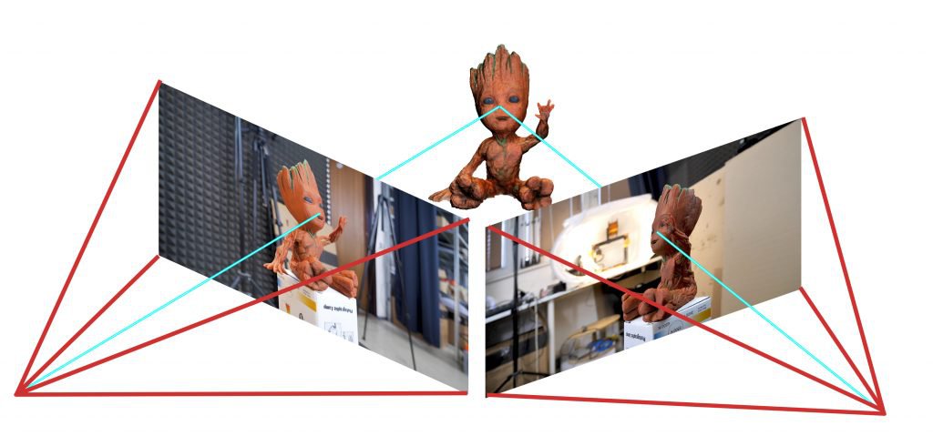
Photogrammetry
Photogrammetry involves taking multiple photographs from different angles and using software to create 3D models of the environment. It's cost-effective and widely accessible, as it only requires a camera and specialized software. However, photogrammetry is highly dependent on lighting conditions and does not provide accurate maps when compared to Lidars. It also requires significant processing time to generate 3D models from 2D images.
Where is Lidar Used?
Lidar technology has found applications in a wide range of industries and fields. Here are some of the key areas where Lidar is used:
- Autonomous Vehicles
Lidar is a critical sensor for autonomous vehicles, providing high-resolution 3D maps of the surrounding environment. It helps vehicles detect and avoid obstacles, recognize traffic signs and signals, and navigate complex roadways. - Forestry
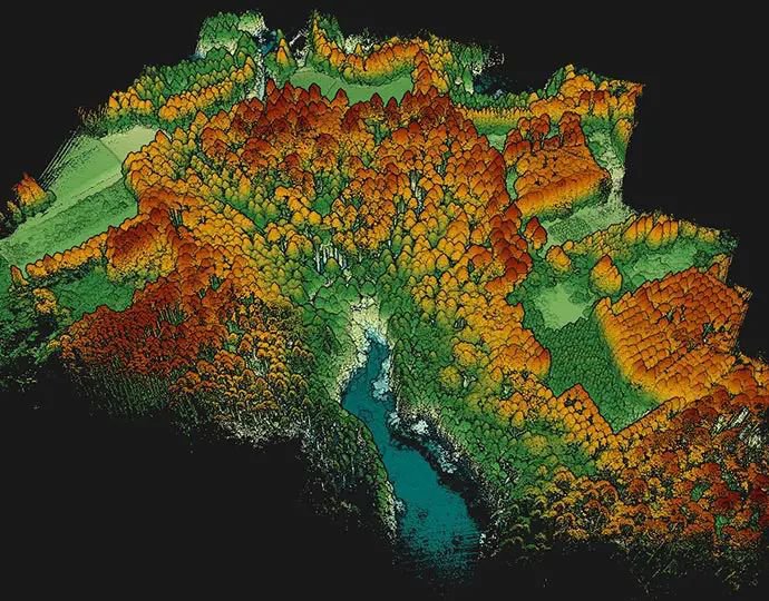
In forestry, Lidar is used to map tree canopies, measure tree heights, and estimate biomass. This data helps with forest management, conservation, and understanding the impact of climate change. - Topography and Mapping
Lidar is used to create detailed topographic maps of landscapes. It can accurately measure elevations and contours, making it useful for surveying, civil engineering, and environmental monitoring. - Archaeology
Archaeologists use Lidar to identify and map archaeological sites, even those hidden beneath vegetation or soil. Lidar can reveal structures and features that are not visible to the naked eye. - Mining and Geology
In mining and geology, Lidar can be used to map terrain, monitor changes in mines, and assess geological features. This data can improve safety and efficiency in mining operations. - Urban Planning
Lidar data is used in urban planning to create 3D models of cities, analyze building heights, and plan infrastructure projects. It also aids in assessing flood risk and disaster preparedness. - Infrastructure Inspection
Lidar is used to inspect infrastructure such as bridges, roads, and railways. It helps identify structural issues and plan maintenance and repairs. - Security and Surveillance
Lidar can be used for security and surveillance applications, such as monitoring perimeters and detecting intruders.
Conclusion
Lidar is a versatile and powerful technology that is revolutionizing various industries. By providing high-resolution, three-dimensional data of the environment, Lidar enables a wide range of applications, from autonomous vehicles and forestry to archaeology and urban planning. The integration of AI and machine learning enhances Lidar's capabilities, allowing for advanced object detection, segmentation, and predictive analytics.
If you are looking to prepare labeled datasets for training Machine Learning models on Lidar data, try out Mindkosh's Lidar annotation platform. It can handle a wide variety of Lidar output - from simple intensity point clouds to dense RGB point clouds. It also allows you to perform annotation for multiple sensors for Sensor fusion use-cases. If you would like more information or want to schedule a demo, leave us a note here, or simply drop us an email at hello@mindkosh.com