LiDAR (Light Detection and Ranging) has become one of the cornerstones of autonomous vehicles, robotics, mapping, and smart city development. By producing detailed 3D point clouds, LiDAR enables machines to perceive their environment with high precision.
However, raw LiDAR data is messy. It needs to be annotated—labeling objects like vehicles, pedestrians, roads, or lane markings—before AI/ML models can learn from it. This makes LiDAR annotation tools essential for anyone building perception systems in 2025.
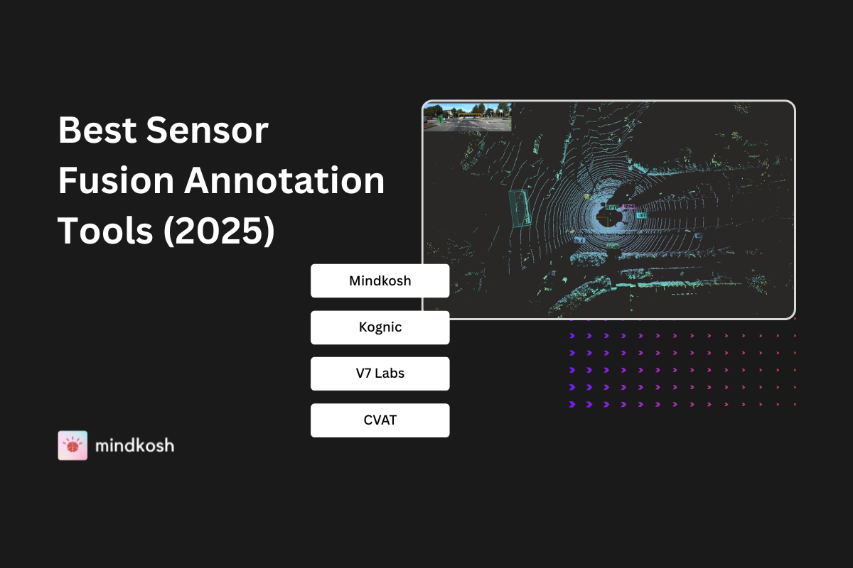
Below we explore the top 5 LiDAR annotation tools in 2025, their unique features, and how they compare—so you can choose the right one for your data pipeline. While these cover all the basic features and tools, if you are looking for a more detailed look at how each of these compare with each other, let us know - we'd be happy to provide detailed comparison sheets to help you choose the right annotation platform for your needs.
Why LiDAR annotation matters?
- 3D perception: LiDAR helps models understand distance, size, and depth.
- Training AI for safety: Autonomous vehicles rely on annotated LiDAR data to detect obstacles in real time.
- Scalability: Efficient annotation tools allow teams to label massive datasets without bottlenecks.
- Sensor fusion: Combining LiDAR with cameras or radar requires specialized tools that support multi-modal data.
The top 5 LiDAR annotation tools in 2025
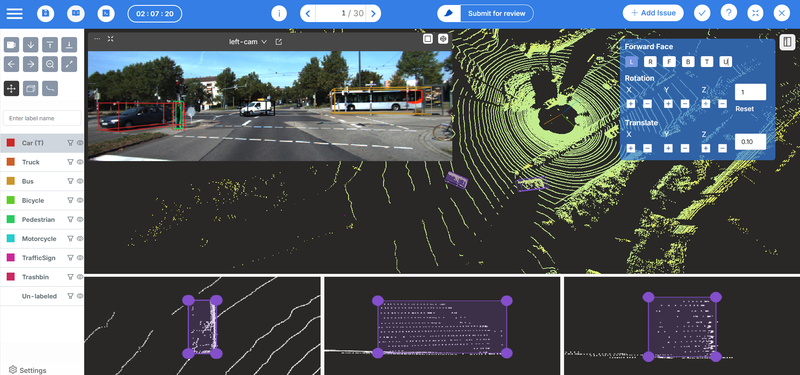
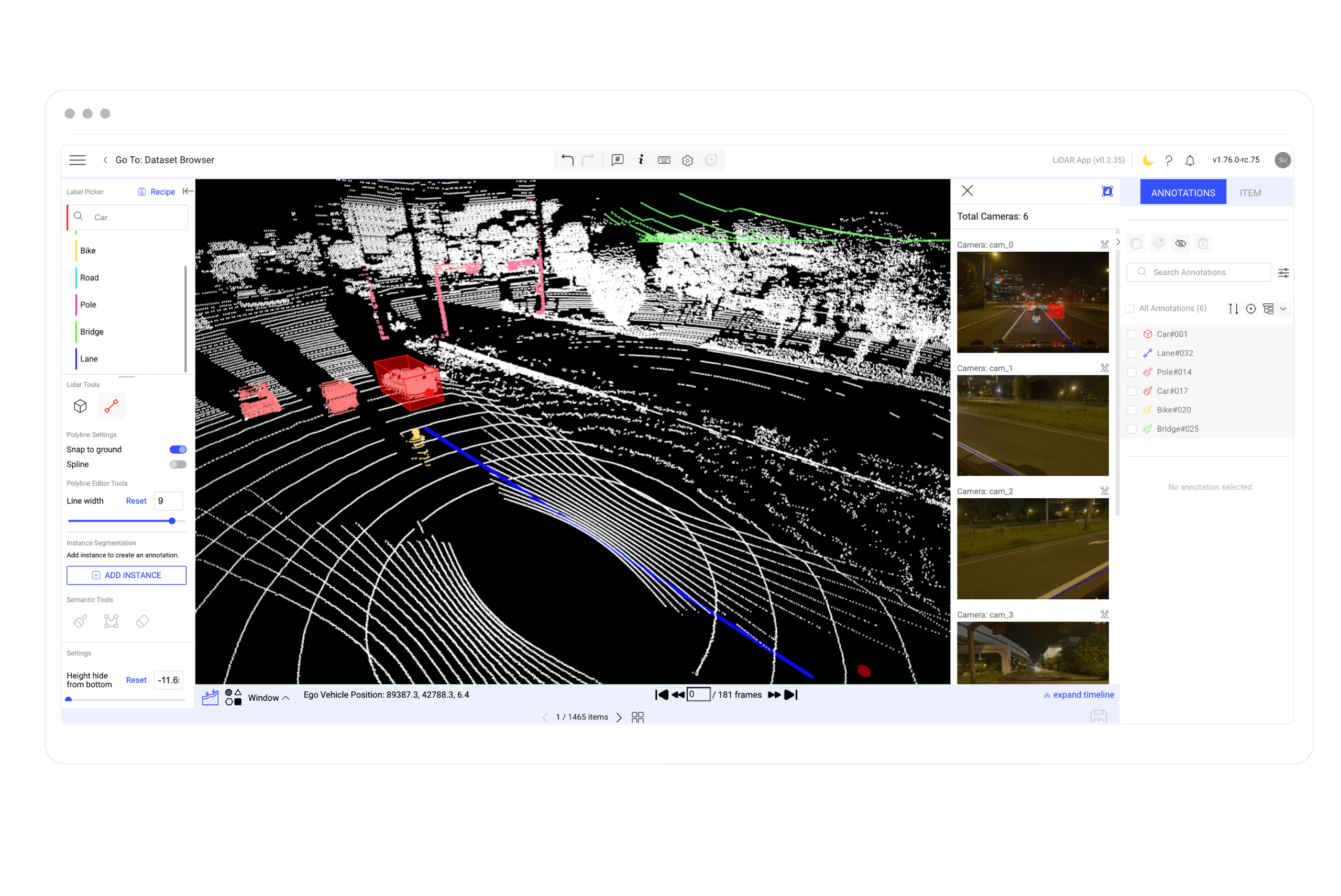
Mindkosh – Comprehensive multi-sensor annotation
Mindkosh combines a comprehensive multi-sensor annotation platform with expert human teams to deliver high quality labels at scale. Mindkosh enables teams to label LiDAR, Radar, RGB, depth and thermal data — all within one interface — with perfect temporal and spatial alignment.
With advanced automation, dense point cloud handling, and quality control pipelines, Mindkosh can handle datasets ranging from complex road scenes to dense indoor warehouses.
Key Highlights:
- Comprehensive 3d point cloud annotation tools.
- Tracking for static/dynamic objects.
- Projection of camera onto point clouds to add color.
- Projection of point cloud annotations onto images
- Automatic segmentation:
- One-click cuboid labeling
- Mask propagation in images to quickly label sequential data.
- Magic Segment to interactively label objects in a few clicks
- Support for dense RGB point clouds with millions of points.
- Customizable annotation workflows and QA tools.
- Seamless integration into AV, robotics, and Geospatial pipelines.
- SaaS (with choice of which region data is stored in), Hybrid SaaS (data stored locally, annotations on cloud) and on-premise setup available.
Best suited for: Enterprises needing high-quality LiDAR annotation with platform + services integration.
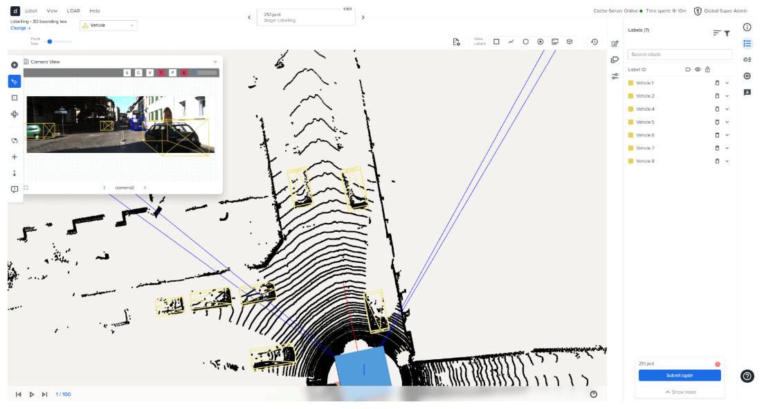
Deepen AI - Enterprise-grade LiDAR platform
Deepen AI offers a mature, enterprise-ready LiDAR annotation solution designed for autonomous driving and robotics. It delivers a well-rounded balance of usability, precision, and calibration support, with deployment flexibility across SaaS and on-premise setups.
Though the platform provides comprehensive 3D labeling tools, it misses some key annotation features like static object tracking and has relatively weaker support for point cloud segmentation. Still, it’s a strong contender for enterprises seeking reliable, structured LiDAR pipelines without a steep learning curve.
Key Highlights:
- Tools for cuboid, polyline, polygon, and segmentation labeling.
- Support for RGB point clouds, filtering by distance/FOV, and fused clouds.
- Calibration and perspective/orthographic projection modes.
- Hybrid SaaS and on-premise setup (data stored locally, annotations on cloud).
Best suited for: Robotics, AV, and industrial AI teams needing structured LiDAR labeling environments
Dataloop.ai – Large-scale LiDAR workflows
Dataloop is a data engine built for scale, combining LiDAR capabilities with multi-modal annotation across images, video, and text. The platform’s clean UI and collaborative design make it ideal for managing massive, sensor-rich datasets in production pipelines.
However, while its SDKs and automation tools are strong, its LiDAR module lacks advanced features like full segmentation control or FOV filtering. It’s best for enterprises that value scalability and integration but can manage without deep 3D customization.
Key Highlights:
- LiDAR annotation studio with strong visualization tools.
- Height & intensity point coloring, segmentation brushes, and interpolation.
- SDKs for upload/download and integration with existing pipelines.
- Sensor fusion capabilities (LiDAR + images).
Best suited for: Teams handling large-scale AV or robotics data pipelines.
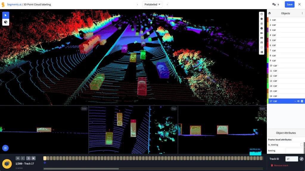
Segments.ai – Speed and automation at scale
Segments.ai is designed for multi-sensor LiDAR–camera fusion, focusing on automation and speed. Its ability to handle sequential 3D datasets and maintain consistent track IDs across frames makes it ideal for robotics and AV workflows.
The platform offers solid automation tools, interpolation, and 1-click 3D-to-2D projections — but falls short in image annotation, and support for depth and thermal images. While Segments.ai is generally great for labeling 3D data; if you need a single platform to label data for different scenarios, Mindkosh offers greater control and depth.
Update: Segments.ai was recently acquired by Uber solutions - its unclear how that will affect the platform and whether it will continue to be available for end-users.
Key Highlights:
- 3D–2D projection in one click and fused 2D/3D viewports.
- Track IDs maintained across modalities and time.
- Automatic interpolation and object tracking.
- Python SDK and webhook integrations for automation loops.
Best suited for: Internal ML teams dealing with a data from a single sensor.
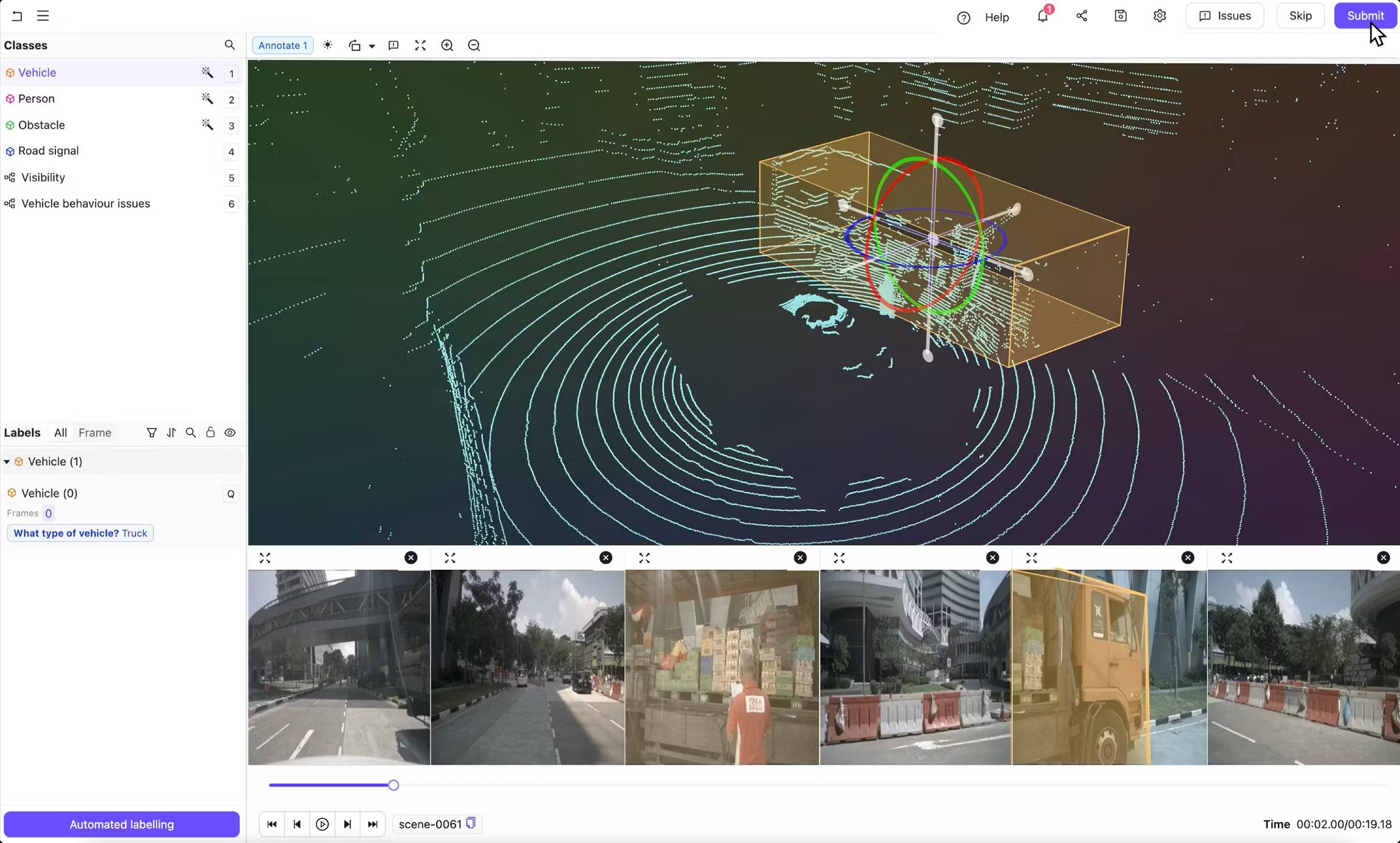
Encord – Multi-sensor AI suite
Encord brings a multi-sensor data suite approach, offering flexibility for teams experimenting with different modalities. It supports various 3D formats and hybrid deployments, allowing users to work with cuboids, keypoints, and basic segmentation.
While its hybrid infrastructure and file format coverage are impressive, its LiDAR tools are still maturing — with manual tracking, limited interpolation, and minimal segmentation control. Encord is great for early-stage teams exploring 3D workflows but not yet ready for production-scale annotation.
Key Highlights:
- Support for medical images and strong 2D image annotation support.
- Handles cuboids, keypoints, and polylines for LiDAR.
- Works in hybrid cloud environments (AWS, Wasabi, Oracle).
- Ground snapping for cuboid annotation and fused cloud for labeling tracks.
Best suited for: Robotics or AI teams experimenting with 3D data, not yet at full-scale production.
Conclusion
LiDAR annotation is no longer optional — it’s the foundation for next-generation perception systems in autonomous driving, robotics, and spatial AI.
While platforms like Deepen, Dataloop, and Segments.ai offer strong capabilities, Mindkosh stands out for its strong support for a large number of sensor types, automation tools, and end-to-end integration, helping teams accelerate model development without sacrificing quality.
If you’re ready to scale your LiDAR annotation pipeline with accuracy and efficiency, Mindkosh can be your trusted partner.