When it comes to LiDAR annotation, much of the industry’s focus has traditionally centered around cuboids (3D bounding boxes) and semantic/instance segmentation of point clouds—methods that label volumetric objects like cars, pedestrians, trees, and buildings. These approaches are excellent for recognizing and localizing object-based entities, but they fall short when we need to accurately model the linear structures that define the geometry of environments: roads, curbs, guardrails, power lines, lane markers, and more.
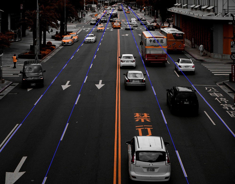
In many machine perception and mapping tasks, understanding not just what exists in the scene, but where, how, and how precisely it lies—makes all the difference. Linear features carry essential structural information for applications ranging from autonomous navigation, infrastructure mapping, to HD map creation. That’s where polyline annotation comes in. Instead of loose volumetric shapes, polyline annotation allows annotators to trace connected line segments in 3D space, capturing thin, elongated features with far greater fidelity.
By adding structure to inherently structureless data, polylines enable systems to understand the geometry and topology of environments in a way cuboids and pixel-level segmentation cannot. This blog explores exactly what polyline annotation is, why it’s transformative for LiDAR-based workflows, the challenges it brings, and how next-gen tools—like Mindkosh’s upcoming polyline annotation module—are making 3D linear labeling intuitive, efficient, and context-rich.
What is polyline annotation?
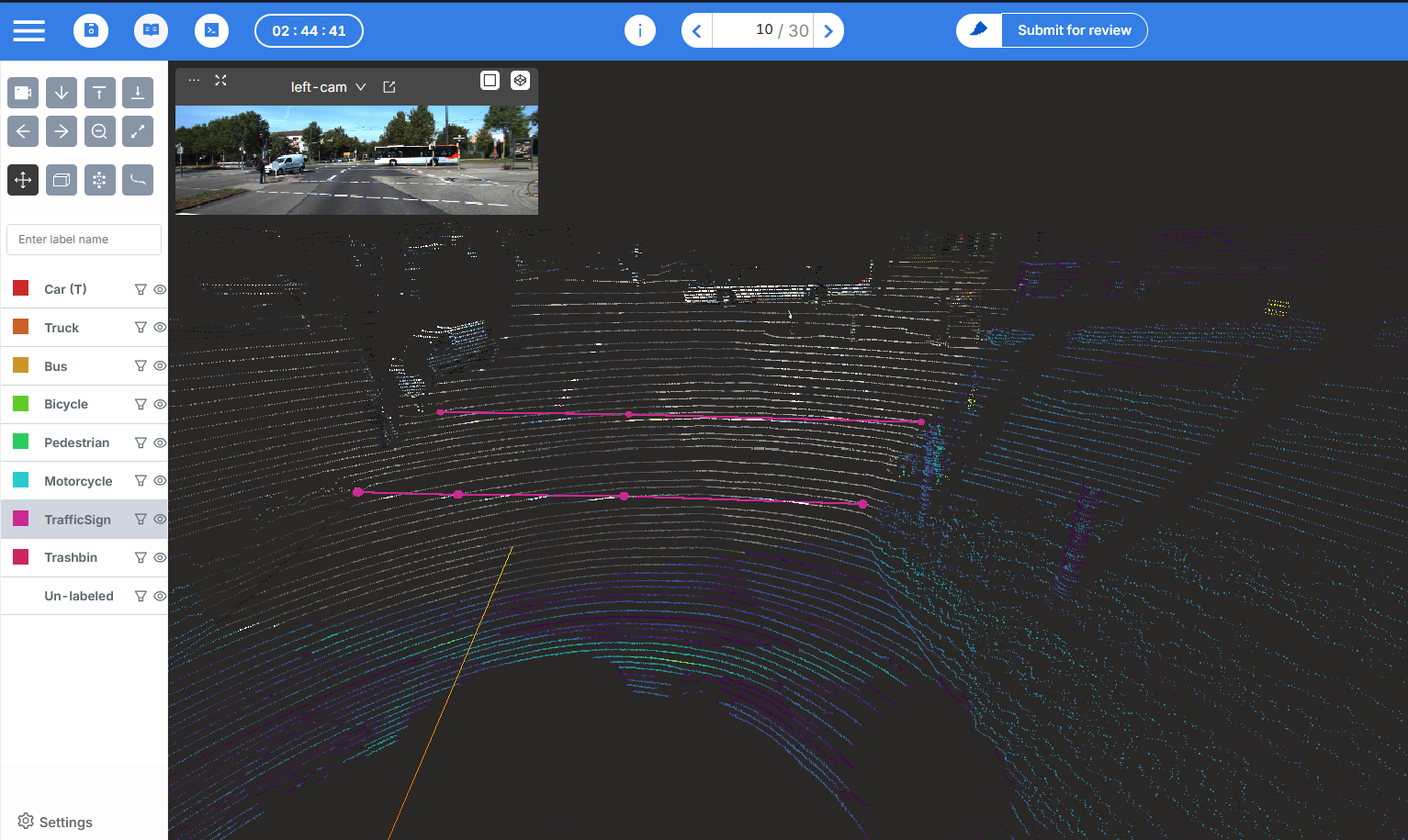
A polyline is a continuous series of connected line segments defined by a sequence of vertices. In 2D, you might think of tracing the outline of a building or the path of a river on a map. Transferring this concept to 3D, a polyline becomes a spatial skeleton—composed of multiple 3D points—that accurately traces edges, lines, and curves within a scene.
In LiDAR applications, polylines are invaluable for annotating:
- Road lane markings
- Curbs and pavements
- Guardrails and barriers
- Cables, power lines, and pipelines
- Rail tracks
- Utility lines and conduits
Rather than drawing cuboid wrappers around line-like objects (which would be bulky and imprecise), annotators can use polylines to follow their exact geometry—resulting in more compact, accurate, and semantically clear annotations.
2D vs 3D polyline
In 2D annotation tasks (e.g., mapping roads in satellite images), polylines are simple sequences of x,y coordinates lying on a flat plane. While accuracy is still important, the vertical dimension can be ignored or approximated. Making 2D polyline annotation relatively easier.
But in 3D LiDAR annotation, polylines live within a three-dimensional coordinate system, where each vertex has x, y, and z components. This additional dimension introduces:
- Elevation handling: Curbs trace across slopes; cables dip between support towers; lane markings follow gradients.
- Perspective control: When visualizing from different angles, annotators must ensure that the vertices align accurately in 3D space.
- Complex geometry: Highway on-ramps, tight curves, and overlapping lines (e.g., overpasses) must be modeled with segmented, non-interfering polylines.
- Semantic clarity: In crowded scenes, delineating one linear feature from another requires precision in placement and layering.
Thus, 3D polylines drive both technical accuracy and semantic richness, bridging the gap between raw point geometry and structured spatial understanding.
Why polyline annotation in LiDAR is a game-changer
Despite its immense utility, polyline annotation in LiDAR is technically challenging. Annotators must navigate a 3D space full of sparse, noisy, and sometimes ambiguous point clouds to trace features that aren’t always fully visible.
Point cloud sparsity
One of the most significant hurdles in LiDAR annotation is point density. A single LiDAR point cloud may contain millions of points—but those points aren’t uniformly distributed. Distant objects, oblique angles, and sensor limitations can cause:
- Gaps in data along power lines or road edges
- Fragmented visibility in occluded areas
- Poor definition of thin, long features
In such cases, annotators must use contextual inference—drawing lines where physical continuity is expected, even when the data is sparse. This demands skill, experience, and often multi-angle visualization to resolve ambiguities.
Annotation fatigue
Polyline annotation is inherently tedious as it often requires:
- Manually placing hundreds of points across frames
- Continuously adjusting 3D position, elevation, and angle
- Repeating tasks for each frame in long sequences
Fatigue leads to inconsistency, which in turn affects downstream performance in training or validation.
To combat this, modern annotation platforms must introduce semi-automated tools, such as:
- Auto-snap to nearest edge
- 1-click line continuation
- Copy-forward and interpolation features across sequences
When tools are intuitive and efficient, annotators spend less time fiddling with vertices—and more time ensuring correctness.
Challenges in 3D polyline annotation
Polyline annotation isn’t just a novel labeling technique - it’s a foundational enabler for multiple advanced applications. By turning abstract point clouds into structured geometric models, polylines unlock real-world insights that drive automation, safety, and infrastructure intelligence.
Enabling autonomous navigation
In autonomous driving, perception systems must do far more than detect objects. They need to understand drivable space, lane geometry, and navigational constraints. This requires capturing features like:
- Lane boundaries
- Lane centerlines
- Curbs and shoulders
- Median strips
- Guardrails
Polyline annotations provide this structure. They guide the AV’s decision-making process by explicitly outlining boundaries in a way that object detection can’t.
Unlike bounding boxes that encapsulate vehicles or traffic signs, polylines trace the environment’s skeleton, enabling:
- Path prediction based on road curvature
- Precision lane keeping and lane-change strategies
- Semantic localization with HD map overlays
- Edge detection to avoid collisions with curbs or barriers
For instance, without polyline-labeled curbs, an AV might misinterpret a raised sidewalk as drivable—leading to errors. Polylines remove that ambiguity by adding fine-grained linear detail to 3D space.
Infrastructure mapping & urban planning
City planners, civil engineers, and mapping agencies rely on LiDAR to reconstruct urban infrastructure. But volumetric labels like cuboids often fail to capture long, narrow, continuous features—which are essential for:
- Power line mapping
- Pipeline route tracing
- Road centerline modeling
- Bridge and railing outlines
- Street light pole wires
Polyline annotation enables CAD-grade geometric reconstruction of these features. Once traced, these lines can be exported into mapping software like ArcGIS, Bentley, or AutoCAD for design, analysis, and construction planning.
Whether it’s planning fiber-optic cable routes or evaluating street drainage patterns, polylines give cities the line-level control they need.
Better HD maps
High-definition maps (HD maps) power localization and navigation for autonomous vehicles, drones, and delivery robots. HD maps aren’t just about points—they’re about relationships and geometry.
Polyline annotation delivers:
- Lane-level detail, including turn markings, arrows, and crosswalks
- Topological structure, such as road interconnectivity
- Curvature estimation for speed regulation and steering
- 3D road topology, including ramps and vertical transitions
Cuboids can’t define where a road bends or a cable dips—but polylines can. For HD map providers like HERE, TomTom, and NVIDIA Drive, polyline-labeled LiDAR is the backbone of spatial precision.
How Mindkosh makes it easy
We understand the pain points that teams face while annotating complex 3D data. That’s why we’re building tools that not only support polyline annotation—but make it intuitive, fast, and production-ready.
Intuitive polyline drawing in 3D
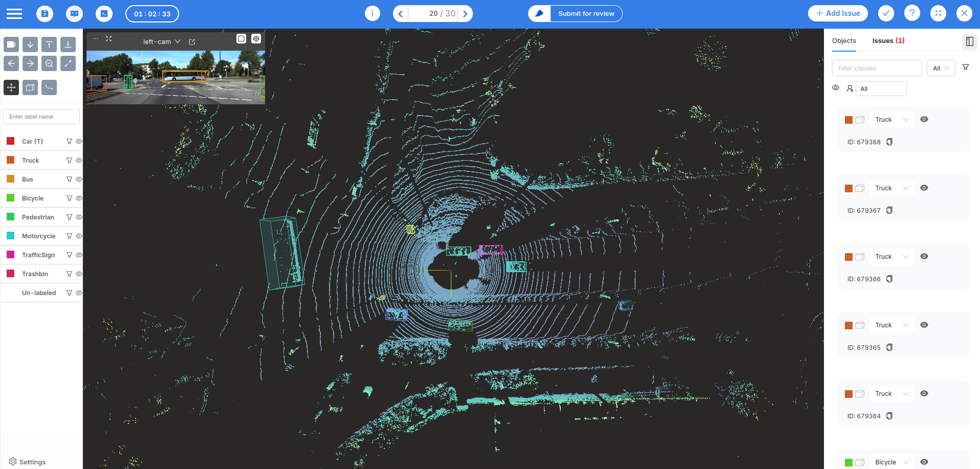
Our LiDAR annotation tool is designed for real-world usability, allowing annotators to:
- Draw and edit polylines directly on point clouds in 3D space.
- Use tools like snap-to-edge and auto-smooth to trace accurate contours quickly.
- Work frame by frame, with the flexibility to refine or add control points with ease.
- Switch between top-down, perspective, or oblique views to resolve unclear geometries.
The UI is optimized for annotation teams—so they can focus on quality, not workarounds.
Smart interpolation
Why redraw the same line across 500 frames? Mindkosh uses smart interpolation, so annotators can:
- Annotate keyframes only (e.g., every 10th frame)
- Automatically interpolate polyline paths between them
- Adjust continuity across frames using an easy-to-navigate timeline
This drastically reduces annotation time and ensures temporal consistency—a must for training autonomous systems that rely on sequential inputs.
Workflow-integrated QA
In many real-world projects, polyline annotation is just one part of a larger task. You may also be segmenting sidewalks, tagging vehicles, or drawing cuboids. That’s why our tool is designed to support:
- Multiple annotation types in a single session
- Customizable workflows and preset QC modes like Honeypot, random checking and multi-annotator setup.
- Task-level issue tracking so reviewers can log problems, suggest corrections, and approve resolved labels
Mindkosh ensures your polyline annotation efforts scale not just in volume—but in accuracy and collaboration.
Real-world use cases
Polyline annotation for LiDAR isn’t a niche use case—it’s at the core of several mission-critical applications across industries.
Annotating lane lines in aerial drone scans
High-altitude drones are increasingly used for city-wide road mapping and asset inspection. However, annotating thin lane markings and road curbs from aerial LiDAR is challenging due to:
- Oblique angles
- Lower point density
- Perspective distortion
With polyline annotation, city planners and contractors can create precise lane-level road maps—helping with traffic engineering, resurfacing plans, and street-level policy enforcement.
Powerline detection in utility management
Electrical utility companies use LiDAR-equipped drones to monitor:
- High-voltage power lines
- Transmission towers
- Tree encroachments
Polyline annotation allows utilities to map wire sag, line tension, and vegetation clearance. This helps:
- Prevent outages due to overgrown branches
- Schedule proactive maintenance
- Avoid costly inspections by humans in dangerous areas
Combining LiDAR polyline data with thermal or visual data also improves multi-modal fault detection.
Road edge detection in ADAS training
For Advanced Driver Assistance Systems (ADAS), especially on rural or poorly marked roads, detecting the road edge is critical.
Polyline annotations:
- Help models understand where the road ends and terrain begins
- Enable edge-case training for narrow roads, construction zones, or snow-covered paths
- Improve lateral planning and emergency maneuvers in unstructured environments
Automotive companies increasingly rely on such annotations to simulate and validate driving behavior under edge-case scenarios.
Conclusion
Polyline annotation for LiDAR is more than a technical upgrade - it’s a strategic necessity in today’s 3D annotation ecosystem.
- Polyline annotations trace the boundaries of linear features like lane lines, power cables, road edges, and curbs.
- Unlike cuboids or semantic segmentation, they offer precise, geometrically accurate outlines in 3D space.
- Use cases span autonomous driving, utility inspection, HD mapping, and smart cities.
- The process is challenging—due to sparse point clouds, annotation fatigue, and complex geometry.
However, platforms like Mindkosh are solving these challenges with intuitive tools, interpolation engines, and QA-ready workflows.
As the world moves toward autonomy, precision, and real-time spatial intelligence, annotation tools must evolve too. Polyline annotation is leading that evolution—transforming raw 3D point clouds into actionable spatial intelligence.
With the right tools, what was once tedious becomes streamlined. What was once ambiguous becomes structured. And what was once time-consuming becomes scalable.