Introduction
Lidar (Light Detection and Ranging) has transformed the field of archaeology by allowing researchers to uncover structures and landscapes that were previously hidden from view. By using laser pulses to create detailed, 3D maps of the earth's surface, archaeologists can now detect ancient ruins and features with unprecedented precision. This technology has been particularly effective in revealing buried or obscured archaeological sites, revolutionizing how we study and understand the past.
Lidar scanners
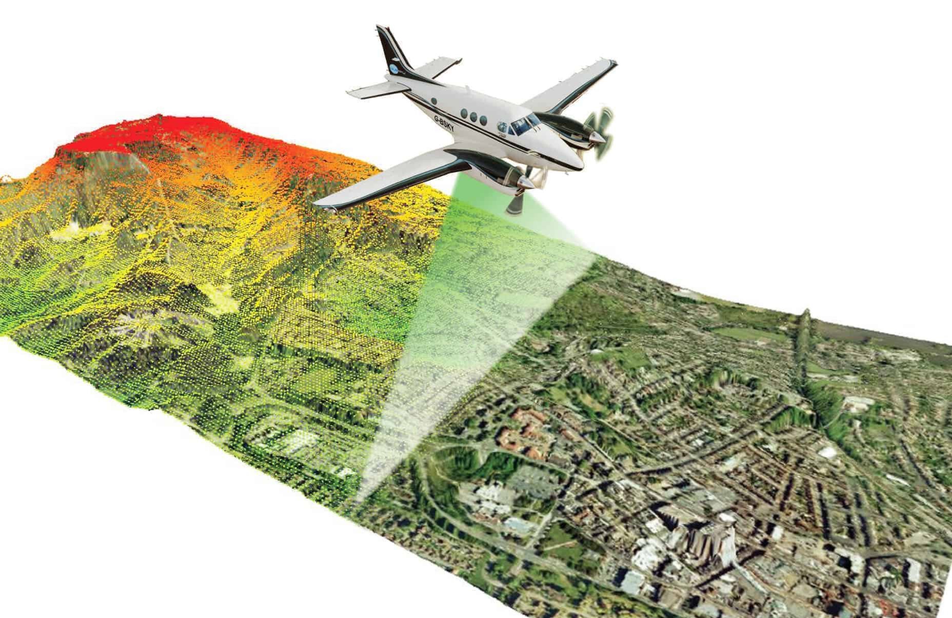
Lidar is a remote sensing technology that measures distances by emitting laser pulses and recording the time it takes for these pulses to reflect off a surface and return. This data is then used to construct highly accurate 3D models of the surface, showing elevations and ground features. Initially developed for meteorological and geographical purposes, Lidar's ability to map large areas with extreme precision has made it invaluable to archaeologists.
Processing and analysing Lidar Data
The raw data collected through Lidar must be processed to make it usable for archaeological purposes. The laser pulses generate billions of points of data, known as a "point cloud." Sophisticated algorithms are then applied to filter out irrelevant points, such as those representing vegetation, to reveal the underlying ground. This process, combined with other geospatial techniques, allows archaeologists to analyze these maps and interpret what may lie beneath the surface.
Lidar in Archaeology
Lidar technology excels at identifying archaeological sites, particularly when ground features are subtle or obscured by dense vegetation or human development. Traditional surveying methods often miss such details, but Lidar can provide accurate topographical data that reveals the contours of ancient structures and landscapes.
Airborne Lidar
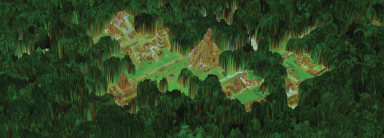
Airborne Lidar surveys are among the most common methods used in archaeological mapping. Typically, a Lidar sensor is mounted on a plane or drone, which then flies over the area of interest. As the aircraft travels, the Lidar system emits rapid pulses of laser light toward the ground. These pulses pass through obstacles such as trees or buildings, allowing the system to map the terrain beneath. By capturing and analyzing the reflected light, researchers can generate highly detailed maps of archaeological sites, even in remote or forested areas.

Advantages of Using Lidar in Archaeology
Lidar technology offers numerous advantages over traditional archaeological methods. It's ability to capture detailed images of the Earth's surface without disturbing the environment has made it a vital tool for non-invasive exploration.
Penetrates forest canopy
One of Lidar’s most remarkable abilities is its capacity to penetrate dense forest canopies, a feature that has been instrumental in uncovering lost cities and structures in tropical regions. By filtering out the signals reflected from tree leaves, archaeologists can isolate ground features, allowing them to detect ruins and ancient pathways hidden under thick vegetation. This has proven especially valuable in areas like Central America, where many ancient Maya cities were discovered under dense jungle.
Produces high resolution data
Lidar provides high-resolution data that can capture minute details, such as small undulations in the ground or faint remnants of ancient structures. This precision allows archaeologists to identify not only large features like walls or buildings but also smaller, subtle formations like terraces, ditches, and paths that might otherwise go unnoticed.
Applications of Lidar Archaeology
The applications of Lidar in archaeology are vast. It has been used to survey large, previously inaccessible areas, uncover lost cities, and map out extensive ancient infrastructure. Lidar has also played a crucial role in environmental archaeology, where it helps researchers understand how ancient societies interacted with their environment. Additionally, Lidar is used to identify patterns of human settlement, track changes in landscape use over time, and assess the impact of natural disasters on ancient civilizations.
Case Studies

The Maya Civilization in Guatemala
One of the most famous uses of lidar in archaeology was in uncovering vast tracts of ancient Maya civilization in the dense jungles of Guatemala. In 2018, researchers used airborne lidar to map over 2,000 square kilometers, revealing more than 60,000 previously unknown structures, including temples, fortifications, and roads. This discovery reshaped our understanding of Maya civilization, suggesting that it was far more extensive and interconnected than previously thought.
Stonehenge and its Surroundings
Lidar has also been employed in European archaeology, notably around Stonehenge in the United Kingdom. While the stone circle itself is well-known, lidar surveys of the surrounding area revealed a complex network of burial mounds, prehistoric pathways, and even hidden monuments that had been buried under centuries of soil and vegetation.
Lost City of the Monkey God
In Honduras, Lidar technology was instrumental in rediscovering the legendary “Lost City of the Monkey God,” also known as La Ciudad Blanca. This site had been elusive for centuries, hidden under dense rainforests. Airborne Lidar revealed intricate networks of plazas, earthworks, and large structures, confirming the presence of an ancient city long thought to be merely a myth.
Challenges and limitations
While Lidar has proven to be an indispensable tool in archaeology, it is not without its challenges. The technology is expensive, and conducting large-scale Lidar surveys can require significant financial investment. Additionally, Lidar data can be difficult to interpret, requiring expertise in both archaeology and geospatial analysis.
Moreover, Lidar cannot always differentiate between man-made and natural features. For example, certain geological formations might resemble human-made structures in Lidar scans, leading to potential misinterpretations. Finally, while Lidar is excellent at mapping the ground surface, It cannot detect features that are deeply buried beneath it, limiting its utility in some contexts where subsurface excavation is required.
Conclusion
Lidar has revolutionized archaeology by providing an unprecedented view of the Earth’s surface. Its ability to penetrate dense vegetation, provide high-resolution data, and cover large areas quickly has enabled archaeologists to discover previously hidden features and gain new insights into ancient civilizations. While challenges remain, the future of Lidar in archaeology is bright, with ongoing advancements promising even more profound discoveries in the years to come.


